


The geographic area of Mexico is extremely iconic not only because of its similarity to a heeled shoe, but also because of the extension of its territory, its ecosystems and the oceans that frame it. However, do you know what the midpoint of the country is? It is the magical town of Tequisquiapan, Queretaro.
This town in Queretaro receives this nickname by virtue of a monument that was built with the intention of baptizing it as the center of Mexico.
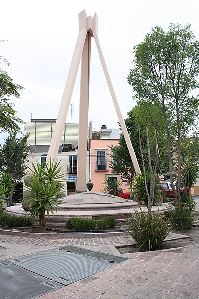
The Tequisquiapan pendulum
He was the then president of Mexico, Venustiano Carranza, who in 1916 issued an agreement to establish the town of Tequisquiapan as the Geographic Center of the Mexican Republic. Declaration that was accepted by the inhabitants of the town.
It is said that after the Mexican RevolutionCarranza used to frequent this town near the city of Querétaro.
His visits were motivated by the tranquility, the colorful architecture and, above all, by the thermal waters of tequisquiapan.
However, it would be in the year 1978 when a plaque and a monument were placed commemorating the title imposed by Venustiano Carranza.
It is important to note that the monument consists of three rectangular-shaped columns that rise towards the sky. All of them form a union at the highest point of the sculpture, from which a metal pendulum shaped like a spinning top is suspended.
In the lower part of the sculpture the geographical silhouette of Mexico is sculpted, so the tip of the pendulum indicates approximately the location of tequisquiapan.
Where is it located?
The location of this sculpture is in the Calle Niños Heroes 17, Centro, 76750 Tequisquiapan, Querétaro.
The monument is also close to Plaza Miguel Hidalgo, one of the attractions of this magical town. In it you will find a large esplanade framed by arches, a fountain, flower boxes and buildings of colonial architecture.
Right there you can also see the Church of Santa María de la Asunción, a pink-colored temple that dates from the year 1847.

the real center
However, according to the National Institute of Statistics and Geography (INEGI)the true center of the country (which is marked on a map) is located in the surroundings of Villa de Cos, in Zacatecas.
This town stands out for its railway past, since since 1884 its railways connected to the capital of Ciudad Juárez.