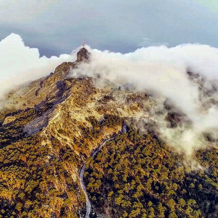
According to experts, Cofre de Perote is an extinct volcano that originated 20 million years ago, in the period known as the Miocene. Likewise, it is located in the state of Veracruz, between the Neovolcanic Axis and the Sierra Madre Oriental; and has an altitude of 4282 meters above sea level; becoming the eighth highest peak in Mexico.
Similarly, it is known as neucampatepetl and this name in Nahuatl means square mountain because on its summit it has a large square rock called the Chest. It is said that this ancient volcano was admired by the famous explorer Alexander von Humboldt on his tour of the American continent.
Cofre de Perote National Park
In 1937 the creation of the Cofre de Perote National Park was decreed as a protected natural area, covering an area of 11,700 hectares belonging to the municipalities of Perote, Xico, Ayahualulco and Acajete, in Veracruz.
Besides, The ecosystem is a pine and oyamel forest where more than a thousand species of flora and fauna live, of which 64 are in some risk category according to Mexican standards and 42 are exotic. Despite being a protected area, the biggest risk facing the park is deforestation, since the forest has been replaced by agricultural crops of corn and potatoes.

Activities inside the park
The site is perfect for outdoor activities such as walking, hiking, mountain biking, rock climbing; flora and fauna observation and mountaineering. It is important to respect the rules of the park; hire a guide to avoid getting lost in the forest and in winter season keep in mind that the hours are reduced and snow may fall, so you have to be extremely careful and wear warm clothes.

Volcanic geology of Cofre de Perote
It is considered a stratovolcano, that is, with a conical shape, a central crater and made up of layers of lava and rock fragments such as slag, sand and ash, the product of different eruptions. It is estimated that it was active about 400 thousand years ago.

Archaeological evidence found on the slopes of the volcano
In 2019, researchers from the National Institute of Anthropology and History (INAH) found three pre-Hispanic settlements in the municipality of Perote: The devil’s hand, La Viborera and Tepeolo; the three located on the lower slopes of the volcano and according to research, date from the year 700 BC
Finally, pyramidal bases, ball courts, a central patio, and a temple were found at the sites. Although it is still unknown to which pre-Hispanic civilization these settlements belonged, it was discovered that their inhabitants worshiped the volcano.